We supply advance professional devices including high-accuracy GPS systems, drones, industrial-grade lasers and more. Contact us at +603 - 5192 0588 or email us at enquiry[at]gpslands.com.my for more information.
  • +603-5192 0588

Orbit 3DM Content Manager

organize & manage, catalog & archive improve & optimize image and point cloud data
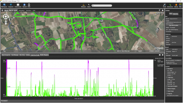
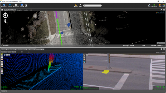
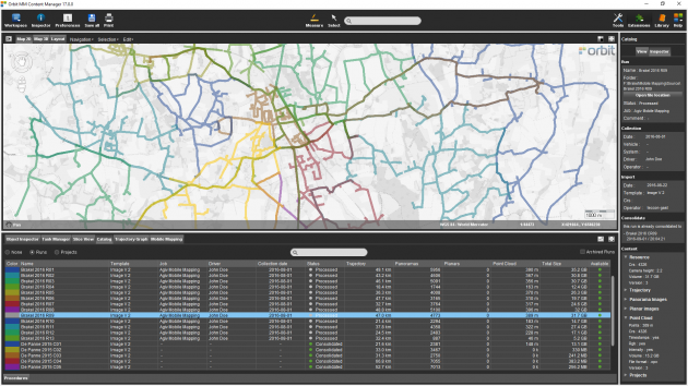
QA/QC, document and report independent deliver ready-made projects after capture upload to share online

A FUNDAMENTAL STEP BEFORE ANY TAGGING, MAP PRODUCTION, OR DATA SHARING

A DESKTOP-BASED SOLUTION TO MANAGE POINT CLOUD AND IMAGERY AFTER CAPTURE

FEATURES

MANAGE COMPANY-WIDE MAPPING DATA

Import and organize all available 3D data at your office, a fundamental step before any tagging, feature extraction, map production, or sharing of data. Based on Orbit ‘s impressive mapping engine, the 3DM Content Manager offers all tools to overview, archive, merge, clean, correct and catalog the collected 3D mapping data for Indoor, Oblique, UAS, and Mobile Mapping jobs.


A FUNDAMENTAL TOOL FOR EVERY 3D MAPPING SERVICE PROVIDER

Before sharing 3D data collected for Indoor, Mobile, or Aerial mapping projects, it is required to optimize the data for performance, use, and further storage. Archiving all available data at company or project level. Cleaning lidar point cloud data, removing ghosts, optimizing image quality, analyzing and reporting positional accuracy are just some of the essential steps in 3D Data Management.


STRONG INDUSTRY SUPPORT

Orbit’s 3D Mapping software supports all known mobile, uas, oblique and terrestrial mapping hardware systems, translating different device setups and specifications into a single user friendly environment. With templates tuned to each vehicle setup, Orbit’s products make import very simple.


3D MAPPING CATALOG

Keep an overview of all available 3D Mapping data
Check a listed 3D data collection on map and availability
View multiple passes, check positional accuracy
Select to open, process, archive, consolidate, deliver


PROCESSING AND OPTIMIZATION TOOLS

point cloud thinning and stripping
image optimization
ortho from point cloud
ortho from spherical imagery
processing task manager
data consolidation & delivery


CORRECT POSITIONAL ACCURACY

analyse positional accuracy by graph, colorized display on map
select any stretch of the trajectory
load ground control points and measure constraints
instant preview of trajectory adjustment
process corrections later
adjustment includes point cloud and imagery positions and angles


CLEAN UP MULTIPLE PASSES, MOVING OBJECTS, NOISE

remove moving objects
remove people
remove unwanted elements
clean up any inconsistancies
consolidate or export point cloud


UPLOAD TO 3D MAPPING CLOUD OR 3DM PUBLISHER

Upload the consolidated Mobile Mapping project directly to 3dmapping.cloud, the Orbit GT SaaS and cloud based online platform, or deliver to the 3DM Publisher, the on-premise solution to share point clouds and imagery online.