


CMP1 Miniphone
CMP1 Miniphone Smaller than the palm of your hand, this tiny, but mighty Android miniphone packs all your smartphone capabilities into a convenient, travel-sized device. Rated IP65, the ...

CT4
CT4 RUGGED ANDROID HANDHELD The CT4 rugged handheld provides ruggedness and functionality in a lightweight, compact package. Featuring 3.5G GSM cellular, Wi-Fi, Bluetooth, GPS, and an 8 ...

CT7
CT7 7-INCH RUGGED ANDROID TABLET Combining the power and versatility of Android with extra ruggedness, the CT7 provides a large, 7-inch display to easily view and collect your data.

Geode
REAL-TIME SUB-METER GPS RECEIVER Looking for a simple sub-meter GNSS solution at an affordable price? With the Geode, you can easily collect real-time, sub-meter GNSS data without the ...
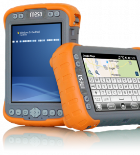
Mesa Rugged Notepad
WORLD’S FIRST RUGGED NOTEPAD Meet the Mesa Rugged Notepad™— featuring the advantages of both a tablet PC and a rugged handheld computer, without the disadvantages of either.

Archer 2
WHEREVER YOUR JOB TAKES YOU From the hammer and anvil, the Archer 2 has emerged faster, smarter, and more sophisticated than ever before, claiming top spot among the most advanced rugged ...

Allegro 2
DESIGNED FOR THE DATA-INTENSIVE From the carefully selected, textured buttons which click with just the right amount of feedback, to the slope of the contours that mimic so perfectly the ...

Mesa 2 Rugged Tablet
YOUR OFFICE, ANYWHERE Introducing… your new office. In a sleek package with the highest-rated protection against water and dust, the Mesa 2 Rugged Tablet can go with you into the ...

Bentley MicroStation
MicroStation is the world’s leading information modeling environment explicitly for the architecture, engineering, construction, and operation of all infrastructure types including utility ...

Bentley Pointools
Quickly visualize, manipulate, animate, and edit point clouds all in a single workflow. This streamlined process helps you decrease production time and increase overall accuracy.


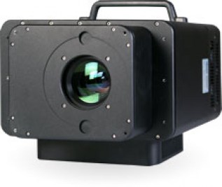
microTABI-640
Portable air/ground broadband pushbroom thermal (MWIR) featuring a small form factor (~2 kg), wide imaging array, and high thermal resolution.

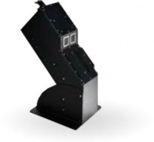
microSASI-384
Portable air/ground hyperspectral pushbroom SWIR featuring a small form factor (~2 kg).

microCASI-1920
Portable air/ground hyperspectral pushbroom VNIR featuring a small form factor (<1.5 kg), 288 programmable channels, and wide imaging array.

TSR-1800
The TSR-1800’s automated thermal anomaly detection is made possible by the TABI imager’s high temperature and spatial resolution capabilities. Flying low (~500 m or 1627 feet above ground ...
CASI-1500h
The CASI-1500 is a visible near Infrared (VNIR) sensor which offers an impressive 1500 pixels across its field of view, allowing you to image a vast area with a single pass, or achieve ...
TASI-600
The TASI-600 is the only commercially available pushbroom hyperspectral thermal sensor system designed specifically for airborne use (to the best of our knowledge). Available with 32 ...
MASI-600
The MASI-600 is the first commercially available Midwave hyperspectral sensor designed specifically for airborne use. As with all of our sensors, the MASI-600 has custom designed optics ...
SASI-1000A
The finest hyperspectral SWIR imaging system available today, ITRES’ SASI-1000A offers 100 bands of low noise, high fidelity imagery over the short-wave infrared spectrum. The custom ...

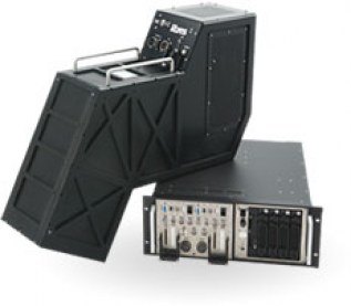
TABI-1800
The TABI-1800 is a thermal broadband imager which follows the same philosophy as the TABI-320 while offering new technologies which improve sensitivity and increase the swath from 320 ...


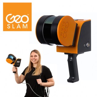
GeoSLAM ZEB Locate
Connect your point cloud to the real world, without the need for external control points


Bentley Descartes
Bentley Descartes is an information modeling software product and an extension of MicroStation, for visualization, vector-to-raster, raster-to-vector conversion, and the management and ...

POSPac MMS 8
Optimized for all environments and platforms (air, land, and marine) and compatible with a variety of mapping sensors, this smart software solution achieves both maximum accuracy and ...

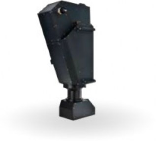
RIEGL VP-1
The RIEGL VP-1 HeliCopterPod is designed to offer smooth integration of airborne laser scanning systems into manned helicopters.

RIEGL VQ-780 II
The Waveform Processing Airborne Laser Scanner RIEGL VQ-780 II provides further increased performance and highest productivity based on a laser pulse repetition rate of up to 2 MHz, ...

RIEGL VQ-480 II
In further development of the RIEGL VQ-480 Airborne Laser Scanner Series – the RIEGL VQ-480 II presents itself in a completly new design that successfully takes up the already proven ...

RIEGL VQ-1560 II
The Dual LiDAR Waveform Processing Airborne Scanning System VQ-1560 II provides further increased performance and highest productivity based on a laser pulse repetition rate of up to 4 ...

RIEGL VQ-840-G
The new RIEGL VQ-840-G is a fully integrated compact airborne laser scanner for combined hydrographic and topographic surveying. The system is offered with an integrated and ...

RIEGL VQ-580 II
In further development of the RIEGL VQ-580 Airborne Laser Scanner Series – the new RIEGL VQ-580 II presents itself in a completly new design that successfully takes up the already proven ...

RIEGL VQ-880-G II
Based on the proven topo-hydrographic airborne laser scanning system VQ-880-G, RIEGL now presents the new VQ-880-G II, which impresses with improved performance of the IR channel and offers ...

RIEGL VQ-1560i and NEW RIEGL VQ-1560i-DW
The new ultra-high performance, fully integrated and calibrated Dual Channel Airborne Mapping System RIEGL VQ-1560i makes use of RIEGL's sophisticated Waveform-LiDAR technology enabling an ...

RIEGL VQ-880-G and NEW RIEGL VQ-880-GH
The RIEGL VQ-880-G is a fully integrated airborne laser scanning system for combined hydrographic and topographic surveying.

RIEGL VQ-780i
The new RIEGL VQ-780i is a high performance, rugged, lightweight, and compact airborne mapping sensor. This versatile system is designed for high efficient data acquisition at low, mid, and ...

RIEGL VUX-1LR
The RIEGL VUX-1LR Long Range is a very lightweight, compact and rugged laser scanner, that was especially designed for airborne surveying missions from helicopter, gyrocopter, and other ...